Drone surveying refers to surveys conducted using drones, or unmanned aerial vehicles (UAVs), to examine buildings or larger objects from the air. Drones are utilized because they can easily access areas that are difficult for humans to reach. Various sensors and equipment can be mounted on drones, with most drone surveys involving photogrammetric digitalization.
Photogrammetric Drone Survey
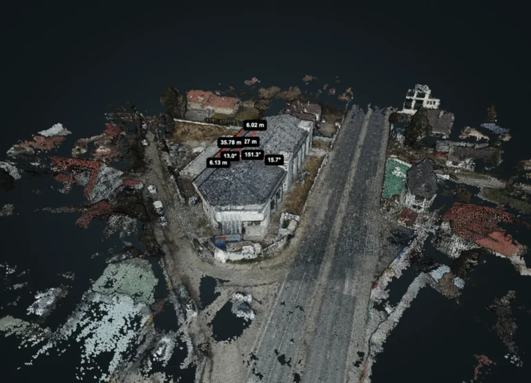
Photogrammetric surveying involves capturing high-quality photos of a certain area or building from various angles with defined overlaps using a drone. This allows us to reconstruct and digitize the building in three dimensions. The result of photogrammetric drone surveys is the creation of a 3D model, which is perfect for visualizing the building and conducting measurements.
Measurements can easily be taken from the digitized building afterward, such as accurately determining distances, angles of inclination, areas, or even volumes. This digital measurement capability greatly facilitates the work of engineers and architects because they can easily perform the necessary measurements remotely and digitally.
Bardi car shop
Orthophoto Creation
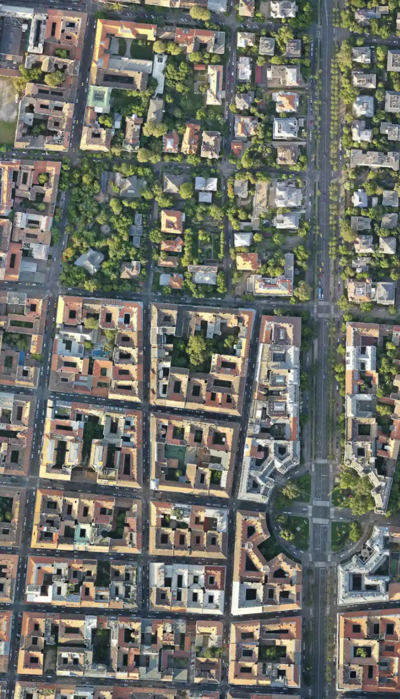
Orthophotos are images that represent a larger area in a map-like top-down view or depict a building’s facade from a side view.We use professional drones to produce high-quality aerial maps. These orthoimages are generated from hundreds of high-resolution aerial images using photogrammetric techniques. The resulting orthoimages are perspective-free images, making them suitable for measurements.
The image details are stored based on a pyramid structure, allowing us to survey large objects or areas with very high accuracy. We can survey entire city blocks, even showing cracks in roads.
The advantage of orthoimages is the quick production process. They are excellent tools for visualizing buildings or larger objects. Orthophoto production is significantly faster and cheaper than other traditional survey methods. orthoimages can be useful in various fields, including construction, real estate development, infrastructure planning, forestry management, and agriculture.
What can drone surveys be used for?
Drone surveys enable us to create precise digital replicas of a given space or building. This makes it easy to understand larger buildings or areas. The resulting 3D model or orthoimage is a perfect tool for conducting measurements, even remotely.
There’s no need to struggle with on-site measurements or condition recording because we can easily do these remotely. Just think about how helpful it is not to have to rent a crane to survey hard-to-reach places.
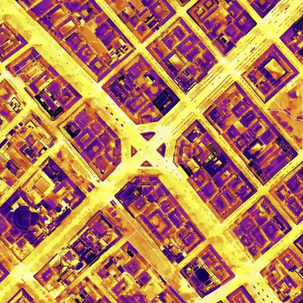
Thermal drone surveys can be conducted using specialized drones equipped with both a camera and a radiometric thermal camera.
With this sensor, we can accurately determine the temperatures of objects or surfaces. Such thermal imaging drone surveys are perfect for examining building insulation but can also be used to analyze the heat emissions of large areas.
Who do we recommend our drone surveying services to?
We primarily recommend our drone surveying services to engineers and architectural designers. It greatly facilitates their work, especially when assessing the current condition of a building before renovation. With our surveys, the building’s current condition can be easily examined digitally, and measurements can be taken for renovation plans. Furthermore, it’s a perfect tool for comprehensively understanding complex buildings, examining parts that would otherwise be difficult to access.
Orthophoto production can be highly useful when high-resolution examination of vast areas is needed. Our aerial maps are produced at much higher resolutions than satellite maps, making it easy to examine large areas in detail.
With our thermal orthophoto service, it’s easy to assess the insulation properties of buildings or compare the heat emissions of different surfaces.
In the summer of 2023, we surveyed the entire District VI using a drone. We made a thermal and a regular orthophoto of the district using a thermal camera drone. (Read more..)
Hungarian National Bank
In 2018, on behalf of an architectural firm, we made external orthophotos of the facades and the roof of the Hungarian National Bank using a drone.
Herend Porcelain Manufactory
In 2023, we created colored 3D models of the newly introduced Herendi porcelains using photogrammetric methods. Some of these can be viewed on our website.
Nyugati railway station
In 2018, in connection with the station’s renovation, we made external orthophotos of all the facades and the hall roof using a drone.
Chief mayor's office
On behalf of an architectural firm, we took external and overhead orthophotos of the office using a drone.
Záhony border crossing point
In 2022, in connection with the border crossing renovation, we created a basic aerial map of the entire border crossing and its surroundings using a drone.
PPG Trilak
In 2023, we made a virtual tour of one of PPG Trilak’s factories.
Orlen Hungary Kft.
In early 2024, we surveyed a petrol station’s advertising column using a laser scanner and a drone on behalf of Orlen Hungary Kft. The new advertising column will be built based on these surveys.
Semmelweis University
In 2019, we took external orthophotos with a drone of the internal medicine, neurology, and urology buildings located on the campus.
In addition to the ones mentioned above, we have numerous satisfied clients by our side.
If you want to order our drone services, first contact us via the contact form, phone, or email. We will prepare our personalized offer within 1 business day. On-site work depends on the size of the building or area to be surveyed, but we usually complete most of our on-site projects within 1-2 business days. Post-processing typically takes up to 5-8 business days, so a complete drone survey with engineering accuracy can be completed within 1-2 weeks from the initial contact.
We provide the completed orthophoto in a georeferenced offline format, which can be viewed in almost any image viewer. Additionally, a map compiled from the orthophotos is provided through the Mapbox external service interface, allowing it to be easily viewed and shared online.