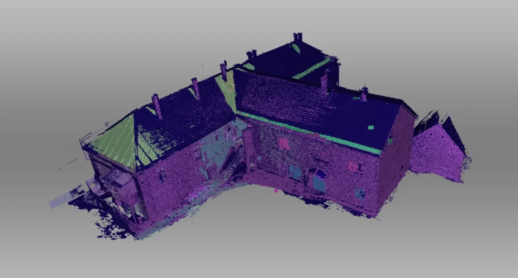
Laser scanning point cloud creation is a spatial data acquisition method that allows us to create digital replicas of buildings and objects with millimeter precision. This technology employs laser distance measurement from the surface of an object or building, enabling spatial reconstruction.
The point cloud stores the spatial characteristics of the given building or object in an extremely detailed manner. Laser point clouds can be used in various applications such as architecture, construction, urban development, and quality control. Point clouds enable examination of 3D models of buildings and objects, as well as precise and detailed measurements.
How is a 3D point cloud created?
The creation of a point cloud is based on the reflection of laser beams emitted by the laser scanner. The laser scanner scans the environment and detects the reflected laser beams from surrounding objects. From these reflected data, the laser scanner calculates spatial coordinates for the points.
During software processing, these points are assembled into a point cloud, which represents the surveyed object in three dimensions. With the laser scanner we use, we can create a point cloud with millimeter precision, facilitating easy measurements. Measurements such as distance, inclination angle, area, and even volume can be taken.
What can the point cloud be used for?
The laser scanner point cloud is a digital replica of an object or building in three dimensions, with millimeter precision. Because it contains very accurate and detailed data, it is entirely suitable for making measurements. From a point cloud, distances, inclination angles, areas, and even volumes can be easily measured.
The huge advantage of our 3D point cloud service is that we can survey anything from small objects to large buildings with engineering precision. Surveys based on such point clouds are faster and less costly than traditional engineering surveys. Our laser point cloud service is an excellent tool for engineers, architects, construction companies, for planning, construction, and renovation work.
Who do we recommend our point cloud creation service to?
Our point cloud creation service speeds up and simplifies measurements in various fields.
For architects and designers, the use of laser scanner point clouds greatly facilitates work by providing clear insight into the topography and terrain of construction sites. Additionally, during renovation planning, we can create a millimeter-accurate replica of the building, making measurements much faster and easier.
For engineering surveys and analyses, laser scanner point clouds are useful tools because we can create highly accurate digital replicas of objects or even buildings. They are very useful for quality control, measurements, and analysis.
Reference list
District VI .Thermal Camera Survey
In the summer of 2023, we surveyed the entire District VI using a drone. We made a thermal and a regular orthophoto of the district using a thermal camera drone. (Read more..)
Hungarian National Bank
In 2018, on behalf of an architectural firm, we made external orthophotos of the facades and the roof of the Hungarian National Bank using a drone.
Ipoly Erdő Ltd.
For Ipoly Erdő Ltd., we surveyed more than 50 hectares of forest with a drone. Using our proprietary software we determined the number of trees, height, volume and basal area.
Herend Porcelain Manufactory
In 2023, we created colored 3D models of the newly introduced Herendi porcelains using photogrammetric methods. Some of these can be viewed on our website.
Nyugati railway station
In 2018, in connection with the station’s renovation, we made external orthophotos of all the facades and the hall roof using a drone.
Gyulaj Ltd.
For Gyulaj Ltd., we have already surveyed more than 30 hectares of forest with a drone. During the drone forestry surveys we measured the number of trees, their height and volume.
Chief mayor's office
On behalf of an architectural firm, we took external and overhead orthophotos of the office using a drone.
Záhony border crossing point
In 2022, in connection with the border crossing renovation, we created a basic aerial map of the entire border crossing and its surroundings using a drone.
PPG Trilak
In 2023, we made a virtual tour of one of PPG Trilak’s factories.
LPP Hungary Kft.
We have carried out several building surveys for LPP Hungary Kft. We created 3D laser scan point clouds and photographic documentation of the buildings.
Orlen Hungary Kft.
In early 2024, we surveyed a petrol station’s advertising column using a laser scanner and a drone on behalf of Orlen Hungary Kft. The new advertising column will be built based on these surveys.
Semmelweis University
In 2019, we took external orthophotos with a drone of the internal medicine, neurology, and urology buildings located on the campus.
In addition to the ones mentioned above, we have numerous satisfied clients by our side.
If you would like to order our laser scanner point cloud service, first contact us via the contact form, phone, or email. We will provide you with a personalized quote within 1 business day. On-site work depends on the size of the building or object to be surveyed; we typically complete most of our on-site projects within 1-2 business days. Post-processing usually takes up to 5-8 business days, so a complete point cloud survey can be completed within 1-2 weeks from the inquiry.
The completed point cloud survey is provided offline, in a predetermined format that can be opened in point cloud viewer software. In addition, the completed point cloud is also transferred to the Sketchfab external service platform, where it can be easily viewed online and shared.